

Your Custom Text Here
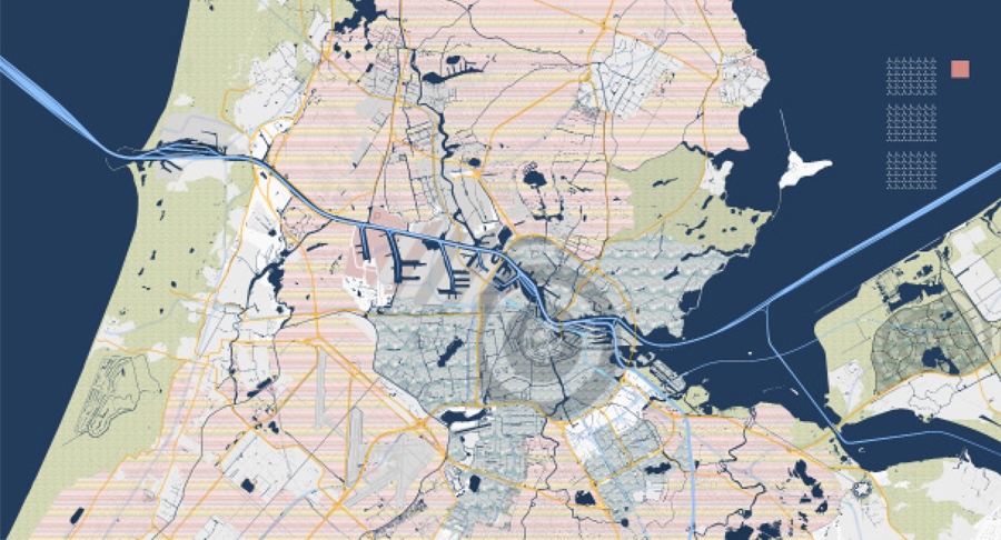
The project was an urban planning / mapping project from our third year of school that focused on the representation and projection of the city of Amsterdam at 5 different scales. The first board, the largest scale, began to identify the underlying urban forces at play within the city and the surrounding area. It sought to highlight the condition of centrumitis in the urban centers, the stratification of the surrounding landscape, and the ongoing battle with land reclamation and rising water levels. Also represented at this scale are the various modes of transportation into and around the city centers. The second board of the series moved down to the 1:250 scale. Here begins our own architectural intervention into the city, stemming from the neighborhood of Ijburg. Drawing from this previously established urban network, we projected our intervention out into the Ijmeer to connect via land bridge to the city of Almeer. Using a network of roadways and varied zoning as our framework, we looked to establish our own monocentric condition, thus alleviating some of the stress on the given monocentricities and shifting the urban condition to one of polycentricity. The scheme also explored some conceptual ideas of aqua farming / tourism, floating market places, and transitional zoning regulations. The third board in the series, the 1:50 scale, moved in to examine the newly created network at the scale of a neighborhood. Here the project shifted to examine strategies for high density housing and became a dissection of the double loaded corridor. By pulling apart this often cramped and anti-social space, I attempted to integrate mixed use programs across multiple floors and create a multi-tiered pedestrian connection to the urban center. The final board, the perspective, shows a projection of what our newly developed centrum could become. To create the massings for the urban center, I took the existing buildings of Ijburg and reoriented them vertically, alluding to a transition away from horizontality to accommodate a more compact urban center. The buildings were also texture-mapped with historically significant works of art which I found fascinating in their attempt to describe a standardized shape or form with a proliferation of strokes and members, in a similar way t0 which architecture uses a composition of many elements to form a cohesive whole. Also it allowed for an assemblage of culture and historicism to be projected onto the new forms. The foreground of the perspective shows my housing scheme and a dissected urban corridor.
The project was an urban planning / mapping project from our third year of school that focused on the representation and projection of the city of Amsterdam at 5 different scales. The first board, the largest scale, began to identify the underlying urban forces at play within the city and the surrounding area. It sought to highlight the condition of centrumitis in the urban centers, the stratification of the surrounding landscape, and the ongoing battle with land reclamation and rising water levels. Also represented at this scale are the various modes of transportation into and around the city centers. The second board of the series moved down to the 1:250 scale. Here begins our own architectural intervention into the city, stemming from the neighborhood of Ijburg. Drawing from this previously established urban network, we projected our intervention out into the Ijmeer to connect via land bridge to the city of Almeer. Using a network of roadways and varied zoning as our framework, we looked to establish our own monocentric condition, thus alleviating some of the stress on the given monocentricities and shifting the urban condition to one of polycentricity. The scheme also explored some conceptual ideas of aqua farming / tourism, floating market places, and transitional zoning regulations. The third board in the series, the 1:50 scale, moved in to examine the newly created network at the scale of a neighborhood. Here the project shifted to examine strategies for high density housing and became a dissection of the double loaded corridor. By pulling apart this often cramped and anti-social space, I attempted to integrate mixed use programs across multiple floors and create a multi-tiered pedestrian connection to the urban center. The final board, the perspective, shows a projection of what our newly developed centrum could become. To create the massings for the urban center, I took the existing buildings of Ijburg and reoriented them vertically, alluding to a transition away from horizontality to accommodate a more compact urban center. The buildings were also texture-mapped with historically significant works of art which I found fascinating in their attempt to describe a standardized shape or form with a proliferation of strokes and members, in a similar way t0 which architecture uses a composition of many elements to form a cohesive whole. Also it allowed for an assemblage of culture and historicism to be projected onto the new forms. The foreground of the perspective shows my housing scheme and a dissected urban corridor.